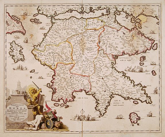
A mare per preparare la prossima avventura.
Grecia, Periplo del Peloponneso.
Lunghe pagaiate, anche con mare mosso, per testare kayak, pagaie, attrezzature e allenamento fisico. Il mare di casa ci riserva condizioni meteo di ogni tipo, l'ideale prima del viaggio.

At the sea to prepare the next adventure.
Greece. Peloponnesus Circumnavigation.
Long paddling, even in rough sea, to test kayaks, paddles, equipment and our physical training . "Our sea" give us all kinds of weather condition, perfect
before the departure.


Faro di Capo Gallo
Cape Gallo Lighthouse


Peloponneso in kayak
Un'altra avventura nei mari della Grecia. Giacomo Della Gatta e Salvatore Bartoli partiranno a metà Giugno da Patrasso e pagaieranno per oltre 500 Miglia (circa 1000 km) attorno a questa isola voluta dall'uomo. Grazie al Canale di Corinto è infatti possibile circumnavigare la "ex penisola".


Questo Blog verrà usato per gli aggiornamenti anche durante la navigazione.
Sarà seguito da Valentina Bonomonte quando le condizioni non lo permetteranno. Anche in caso di problemi per gli aggiornamenti meteo Valentina invierà i bollettini tramite sms.


Diversi i punti di assoluto interesse. Da Capo Matapan (o Capo Tenaro), considerato dai velisti una sorta di Capo Horn del Mediterraneo, al passaggio del Canale di Corinto. Ed ancora la "doverosa" visita ad Olimpia, meta unica per tutti gli amanti dello sport, situata a pochi chilometri dalla costa Ovest.
L'obiettivo del viaggio, in linea con i precedenti, sarà quello di navigare lungo la costa vivendo in pieno contatto con la natura, facendo campeggio nautico, senza alcun appoggio logistico a terra e quindi in totale autosufficenza. I kayak, oltre all'equipaggiamento stivato nei gavoni stagni, saranno dotati di un mini dissalatore e di pannelli solari che consentiranno di avere autonomia sia per l'acqua che per l'energia elettrica (alimentazione GPS, VHF, etc.) punti chiave per ogni tipo di spedizione. Il carico dei kayak sarà comunque ottimizzato al massimo per consentire una navigazione veloce.

Peloponnesus by kayak
Another adventure in the seas of Greece. Giacomo Della Gatta and Salvatore Bartoli will start in mid-June from Patras and paddle for more than 500 miles (1,000 km) around this island desired by man. Thanks to the Corinth Canal it is possible to circumnavigate the "ex peninsula".


This Blog will be used for updates during navigation.
Will be followed by Valentina Bonomonte when conditions does not permit. Even in the event of problems for weather updates Valentina send bulletins via SMS.

Several points of absolute interest. From Cape Matapan (or Cape Tenaro), considered by sailors some sort of Cape Horn of the Mediterranean, the passage of the Corinth Canal. And also the visit to Olympia a "must" and unique destination for all sports enthusiasts, located few kilometers from the west coast.
The purpose of the trip, in line with previous, will be to paddle along the coast living in full contact with nature, by nautical camping, no logistical support from the ground and then in total autonomy. The kayaks, as well as equipment stowed in watertight compartments, will be equipped with a mini water maker and solar panels that will give us autonomy for both water and electricity (power GPS, VHF, etc..) Key points for each type of expedition. The load of kayaks will still be maximized to allow a quick navigation.

Crete's Periplus Slideshow
Clicca e guarda lo slideshow "Crete's periplus" per vedere le immagini più belle della circumnavigazione di questa selvaggia, splendida e ventosa isola.
Sia il vento, il temuto Meltemi, che il mare, spesso mosso, hanno reso la navigazione più impegnativa del previsto.


Crete's periplus Slideshow
In the month of June, Salvatore Bartoli and Giacomo Della Gatta have concluded the Circumnavigation of this wild, beautiful and windy island. Both the wind, the feared Meltemi, that the sea, often slight, made navigation more challenging than expected.
Click on the slideshow "Crete's Periplus" to see the best photos of the trip.


19° giorno ed ULTIMO GIORNO 29 giugno 2008 ARRIVATI! Makrigialos- Myrtos 20 miglia (37 km) s.m.s. di Giacomo
"Mare calmo, anche se in alcuni momenti violenti raffiche di vento da Nord Ovest ci spingono verso il largo. Le consideriamo un "saluto" da parte di un'isola così difficile e selvaggia. Esaltati dalla vicinanza della nostra meta pagaiamo con poche brevi soste per arrivare prima possibile. L'emozione dell'arrivo ci ripaga dalle fatiche. Brindiamo a questa e....alle prossime avventure. CIAO".
Mentre pubblico questo post Giacomo e Salvo sono già di rientro sulla nave per Bari, domani o al massimo dopodomani saranno a casa....non mancate di visitare il blog per vedere le foto e per sentire i loro racconti in diretta e per porgere tutte le vostre domande.

19th day and LAST DAY ARRIVED! Makrigialos-Myrtos 20 miles (37 km) Giacomo' s s.m.s.
"Sea calm, although in some moments violent gusts of wind from the North West prevent us to paddle. We consider them a "greetings card" from an island so hard and wild. We are so excited to be so close to the end of our trip and so we paddle stopping only for few minutes and trying to arrive as soon as possible. The emotion rewards us from the hard work. We celebrate this and ... next adventures. Good bye. "

While I'm publishing this post Giacomo and Salvo are in the way to home, tomorrow or at last after tomorrow they will be at home .... Don't forget to visiting the blog next days to see the photos and to hear their stories live and to ask them all your questions.
18° giorno 28 giugno 2008 Kato Zacros-Makrigialos 22 miglia (41 km) s.m.s. di Giacomo
Finalmente una giornata con mare quasi calmo. Ci godiamo l'ultimo tratto di costa selvaggia. Navighiamo verso ovest. Dopo capo Goudura la costa diventa meno interessante per la forte presenza di serre e costruzioni. Con la testa ormai all'arrivo, previsto per domani, pagaiamo pensando ai punti dell'isola per noi più belli. Abbiamo l'imbarazzo della scelta...."

18th day Kato Zacros-Makrigialos 22 miles (41 km) Giacomo's s.m.s..
Finally we spent a day with sea almost quiet. We enjoy the last stretch of wild coast paddling towards west. After Cape Goudura the coast becomes less attractive becouse the strong presence of greenhouses and buildings. Now we think only to reach the point of arrival, scheduled for tomorrow, we paddle and remeber the most beatiful places we saw. They are to many......"

17° giorno 27 giugno 2008 Capo Mavros- Kato Zacros 22 miglia (41 km) s.m.s. di Giacomo
"All'alba ci dirigiamo verso Capo Sidheros. Il mare è già al limite, bastava un pò di ritardo e non saremmo riusciti a passare.Finalmente prue verso sud! Ci fermiamo a Finikodasos, spiaggia con un bellissimo palmeto. Sembra di essere in Africa. Proseguiamo fino a Zacros. Durante la navigazione incredibili raffiche di vento scendono dalle montagne. Riusciamo a tenere a stento le pagaie in mano"

17th day on June 27, 2008-Cape Mavros Kato Zacros 22 miles (41 km) Giacomo's s.m.s.
"At the sunshine we paddle towards Cape Sidheros. The sea is already at the limit, just a little later and we would not be able to cross the Cape. At least direction to South! We stop at Finikodasos, a beautiful beach with palm trees. It seems to be in Africa . We continue to paddle to Zacros. During the navigation incredible gusts of wind down from the mountains. We can take hardly the paddles in hand "
16° giorno 26 giugno 2008 Moholos - Capo Mavros N 35'.16.180 EO 26'.14.249 21 miglia (39 km) s.m.s. di Giacomo
"Navighiamo tranquilli solo prime ore del mattino. A Capo Faneromenis troviamo il mare tempestoso, anche alcun barche a vela navigano con difficoltà. Dopo più di 3 ore di "battaglia" ci ridossiamo a Sitia. Nel pomeriggio avanziamo verso Capo Sidheros. Ci fermiano nell'ultima spiaggia possibile, all'alba di domani ci aspetta il Capo più impegnativo dell'isola."

16th day on June 26, 2008 Moholos - Cape Mavros N 35.16.180 EO 26'.14.249 21 miles (39 km) Giacomo's s.m.s.
"We paddle quiet only during the first hour of the morning. At Cape Faneromenis we find the sea on storm, also sailboats sail with difficulty. After more than 3 hours of" battle " we repair at Sitia. In the afternoon we paddle towards Cape Sidheros. We stop in the "last possible beach", tomorrow at sunset the most difficolult Cape of Creta wait for us.
15° giorno 25 giugno 2008 Capo Hersonisos- Mohlos 38 miglia (70km) s.m.s. di Giacomo
"Navighiamo spediti verso est.A Capo Drepani una grossa termica crea mare molto mosso. Avanziamo con difficoltà. Finalmente nel pomeriggio arriviamo a Spinalonga, isola fortezza nel golfo di Agio Nikolaos. Decidiamo di Tagliare il golfo di Mohlos. Causa corrente contraria non prevista arriviamo alle 22,30 dopo oltre un ora di navigazione notturna (kayak a luci accese)."

15 Day on June 25, 2008 Cape Hersonisos-Mohlos 38 miles (70km) Giacomo's s.m.s.
"We paddle to est. At Cape Drepani we find rough sea becouse thermal wind. We paddle with difficulty. Finally in the afternoon we arrive at Spinalonga, island fortress in the Gulf of Agio Nikolaos. We decide to cut the Gulf of Mohlos. We paddle against the current and we arrive to 22.30 after more than an hour of navigation in the night (kayak with light on). "

14° giorno 24 giugno 2008. Agia Pelagia-Capo Hersonisos. s.m.s. di Giacomo
"Anche oggi il Meltemi rallenta la nostra navigazione. Davanti al porto di Iraklion il mare diventa in breve forza 6. Decidiamo di riparare dentro il porto, dove rimaniamo in attesa che il vento molli almeno un pò. Siamo ospiti di un piccolo cantiere nautico il cui capo simpaticamente ci ripete che siamo pazzi. Solo alle 17,00 proseguiamo per recuperare un pò."

14th day on June 24, 2008. Agia Pelagia-Cape Hersonisos.Giacomo's s.m.s.
"Even today the Meltemi makes slower our navigation. In front of the port of Iraklion the sea becomes in a short time power 6. We decide to repair inside the port, where we wait for a better wind. We are guests of a small nautical club where the owner even repeats that we are crazy. Only at 17.00 we are abble to paddle a little more. "
13° Giorno 23 giugno 2008.Rethimnon- Agia Pelagia 30 miglia (55 km). s.m.s. di Giacomo
"Finalmente un pò di mare a favore. Anche se ancora mosso il mare è navigabile e soprattutto con il vento alle nostre spalle. Navighiamo spediti rotta est anche perchè questo tratto di costa non ci attrae più di tanto. Facciamo sosta nel paesino di Bali, poi fino ad Agia, a poche miglia da Iraklion"
13th Day Rethimnon-Agia Pelagia 30 miles (55 km). Giacomo's s.m.s.
"Finally we have a favourable sea. Although still rough, the sea is navigable and above all we have the wind behind us. We paddle toward east also because this stretch of coast is not very beatiful. We stop in the village of Bali, then up to Agia, a few miles from Heraklion."